
East Africa is heading into one of its most closely watched rainy seasons in years.
The reason is thousands of kilometres away in the Pacific Ocean, where an intensifying El Niño is expected to reshape rainfall patterns across the Greater Horn of Africa.
But this is not simply a story about more rain.
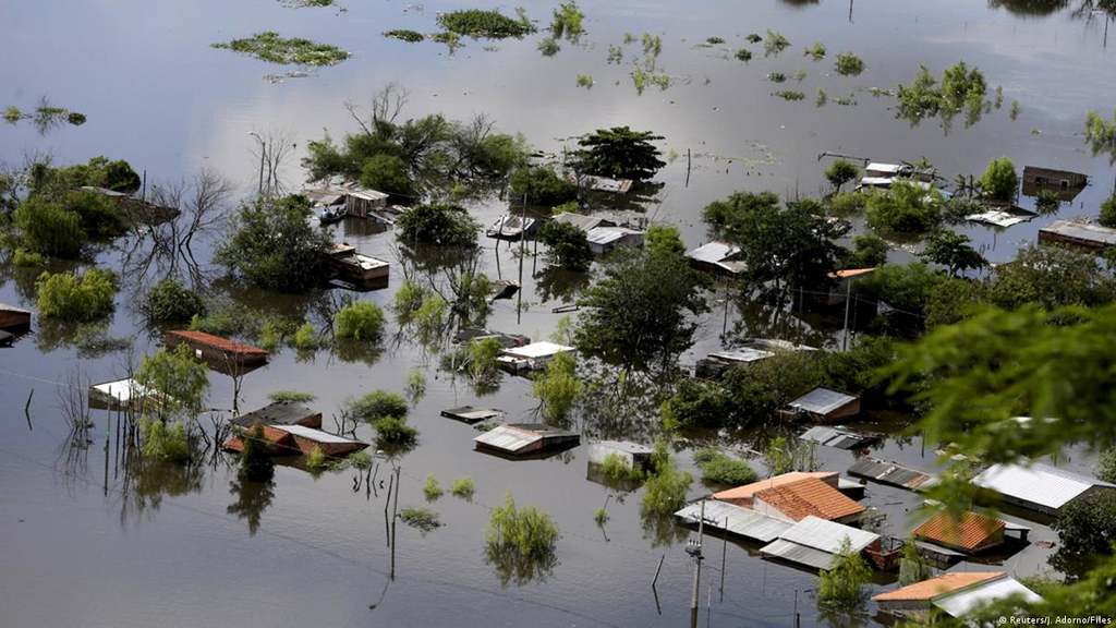
For millions of people in Kenya, Somalia, Ethiopia, Uganda, Tanzania, Rwanda and Burundi, the coming months could bring a complicated trade-off: much-needed water after dry conditions, but also a heightened risk of floods, landslides, disease and damage to homes and infrastructure.
The latest regional outlook issued by the IGAD Climate Prediction and Applications Centre (ICPAC) points to wetter-than-normal conditions across large parts of the region during the October-to-December season.
The World Meteorological Organisation (WMO), in an update published on August 19, said the Greater Horn of Africa is expected to be warmer and wetter than usual during the final quarter of 2026 as El Niño strengthens.
That makes the next few weeks critical for preparedness.
So, what exactly is El Niño?
El Niño is a natural climate pattern that begins with unusual warming of surface waters in the central and eastern tropical Pacific Ocean.
That warming changes the relationship between the ocean and atmosphere. Winds shift. Clouds form in different places. Rainfall patterns move.
The effects can eventually be felt thousands of kilometres away.
El Niño is part of the El Niño-Southern Oscillation (ENSO), which also includes its cooler counterpart, La Niña.
Importantly, El Niño does not mean the whole world gets hotter or wetter in the same way. Its effects depend on the region, the time of year and other climate systems operating at the same time.
That distinction is particularly important in East Africa.
A very strong El Niño is now more likely
The US National Oceanic and Atmospheric Administration's Climate Prediction Center has sharply raised its expectations for the strength of the current event.
Its August outlook puts the probability of a very strong El Niño during October-December 2026 at 95 per cent, based on its Relative Oceanic Niño Index strength forecast. The forecast also shows a 90 per cent probability for the very strongest category during November-January.
Reuters reported earlier this month that US forecasters put the probability of a very strong event in the latter part of 2026 at more than 90 per cent, with a 69 per cent chance that the event could reach historically exceptional intensity.
But there is an important caveat.
The strength of El Niño does not automatically determine how severe its effects will be in a particular country. NOAA itself cautions that a stronger ENSO event can increase confidence in some regional impacts, but it does not guarantee them.
That is why local and regional forecasts remain more useful for planning in Kenya and its neighbours than simply looking at the headline strength of El Niño.
East Africa is facing two very different seasons
This is where the story becomes particularly important for the region.
ICPAC's outlook describes the remainder of 2026 as a dual climate risk.
From July to September, much of the northern Greater Horn is expected to remain unusually dry. Parts of Ethiopia, Sudan, South Sudan, Uganda and western Kenya are among the areas facing depressed rainfall and warmer conditions.
In central and northern Ethiopia, ICPAC's earlier long-range forecast placed the probability of below-normal rainfall as high as 70 to 90 per cent.
Then the picture changes.
For October to December, the forecast points towards substantially wetter conditions across much of Kenya, Uganda, Rwanda, Burundi, Tanzania, Somalia and parts of Ethiopia. ICPAC's model projections put the likelihood of above-normal rainfall at roughly 70 to 90 per cent or higher in several areas.
In parts of eastern Kenya, southern and western Somalia and eastern Ethiopia, the probability of above-normal rainfall is even higher than 90 per cent in the long-range outlook.
That means a region dealing with water stress in one season could be dealing with excess water only a few months later.
Kenya is firmly in the zone to watch
For Kenya, the October-to-December rains — commonly called the short rains — are crucial.
WMO says the season can account for up to 70 per cent of annual rainfall in parts of Kenya, Ethiopia and Somalia. In parts of Rwanda, Burundi, Tanzania and Uganda, it can contribute up to 40 per cent of annual rainfall.
The latest forecast gives central Kenya, north-eastern Kenya and parts of the Lake Victoria Basin particular reason to pay attention.
ICPAC's outlook indicates a high likelihood of seasonal rainfall exceeding 400 millimetres in parts of central Kenya, the Lake Victoria Basin, central and southern Somalia, Burundi, western Rwanda and western Tanzania.
For farmers and pastoralists, that could be welcome news.
More rain could improve soil moisture, restore pasture, replenish rivers and groundwater and help communities recover from earlier dry conditions.
But rain is only beneficial when it arrives at a manageable pace.
The flood risk is the other side of the forecast
Heavy rainfall falling within a short period can overwhelm drainage systems, rivers and already vulnerable settlements.
ICPAC warns of increased risks of surface runoff, flash floods and landslides, particularly in hilly areas. Excessive rain could also cause waterlogging, crop damage, livestock losses and destruction of infrastructure.
The concern is not theoretical.
The region has seen the consequences of exceptionally wet El Niño seasons before.
1997 remains one of the clearest warnings.
That year's El Niño was followed by devastating rains across parts of East Africa, with major flooding in Kenya, Somalia and Ethiopia. The disaster caused widespread displacement and damage and was followed by a serious Rift Valley fever outbreak.
The 2026 outlook also identifies 1997 and 2023 as useful analogue years because of similarities in Pacific conditions and rainfall patterns. But ICPAC is careful to stress that every El Niño is different and that the current forecast, rather than historical comparisons, should guide decisions.
It is not only a flood story
The health consequences could be significant.
Flooding can contaminate water sources and disrupt sanitation, increasing the risk of waterborne illnesses. Standing water can also create favourable conditions for mosquitoes and other disease vectors.
ICPAC's regional assessment specifically flags increased risks of vector-borne diseases affecting both people and livestock if the wet conditions become excessive.
Flooding can also make it harder for people to reach health facilities.
Roads may become impassable. Bridges can be damaged. Communities can become temporarily cut off from markets, schools and medical services.
For farmers, meanwhile, more rain is not automatically the same as a better harvest.
Too little rain can destroy crops. Too much can wash them away.
The Indian Ocean could add another layer
El Niño is not acting alone.
Scientists are also watching the Indian Ocean Dipole (IOD), another climate pattern involving differences in sea-surface temperatures across the Indian Ocean.
WMO says a positive IOD phase is expected to develop during the August-to-October period. Together with El Niño, it could reinforce wetter conditions over parts of East Africa during the short rains.
However, the IOD has carried uncertainty in earlier forecasts, which is another reason not to treat long-range predictions as guarantees.
Weather agencies will continue updating their assessments as the season approaches.
What should Kenyans expect?
Not a single wall of rain.
The forecast is probabilistic. Conditions will vary considerably from county to county and from one week to another.
Some places could receive beneficial rainfall. Others could experience destructive downpours.
The onset is also expected to vary. WMO says early-to-normal onset is more likely across much of Somalia, central and eastern Kenya, southern Ethiopia and most of Tanzania.
That is why the next stage of forecasting will matter.
National meteorological agencies will issue more detailed country-level and local forecasts as October approaches. ICPAC says its regional outlook should be used alongside shorter-range forecasts, which are more useful for decisions such as when to plant, move livestock or prepare for flooding.
The WMO is scheduled to issue its next global El Niño update on September 3, 2026.
The real warning is about preparedness
For East Africa, the coming El Niño should not be viewed simply as a disaster waiting to happen.
It could also bring a chance to replenish water supplies, restore grazing land and support agriculture after dry conditions.
The danger comes when preparedness falls behind the weather.
Communities in flood-prone areas need early warnings that reach them in time. Farmers need local forecasts rather than relying solely on seasonal predictions. Authorities need to clear drainage systems, identify evacuation routes and monitor rivers and dams.
Health officials also need to prepare for the knock-on effects of flooding.
The lesson from previous El Niño seasons is straightforward: the same rain that saves a drought-hit farmer can flood another family's home.
East Africa's challenge in the months ahead will be making sure the first outcome is maximised — while preparing seriously for the second.
You may also like
Category: News
Related Video: What Dangote’s proposed Lamu oil refinery could mean for East Africa
Related Explainer: Explainer: Why Kenya is moving hospitals to HMIS and what it means for SHA patients
About the Author
Maureen Onyango is a journalist passionate about storytelling, life coaching and spiritual lessons. She studied at the Kenya Institute of Management and enjoys telling stories that inform, inspire and empower communities.
 Facebook
 Twitter / X
 WhatsApp
 LinkedIn
 Telegram
 Reddit