
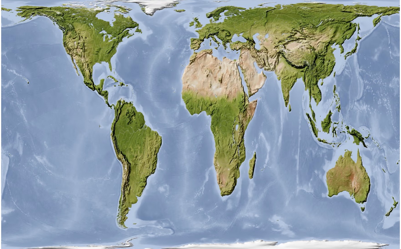
The United Nations General Assembly has backed a historic push to change how the world is represented on maps, supporting a move away from the centuries-old Mercator projection that dramatically understates Africa’s size.
The resolution, spearheaded by Togo as part of the wider African-led #CorrectTheMap campaign, promotes the use of map projections that more accurately represent the relative land area of continents, including the 2018 Equal Earth projection.
The vote could eventually influence how world maps appear in schools, public institutions and digital platforms, although the resolution does not legally prohibit countries or organisations from continuing to use Mercator maps.
The UN had scheduled action on the draft resolution, titled “Correct the Map: Rebalancing global cartographic representation and promoting equitable representation of the world’s regions, particularly Africa,” during its General Assembly plenary meeting in New York on Friday, September 4.
Why Africa looks much smaller on familiar world maps
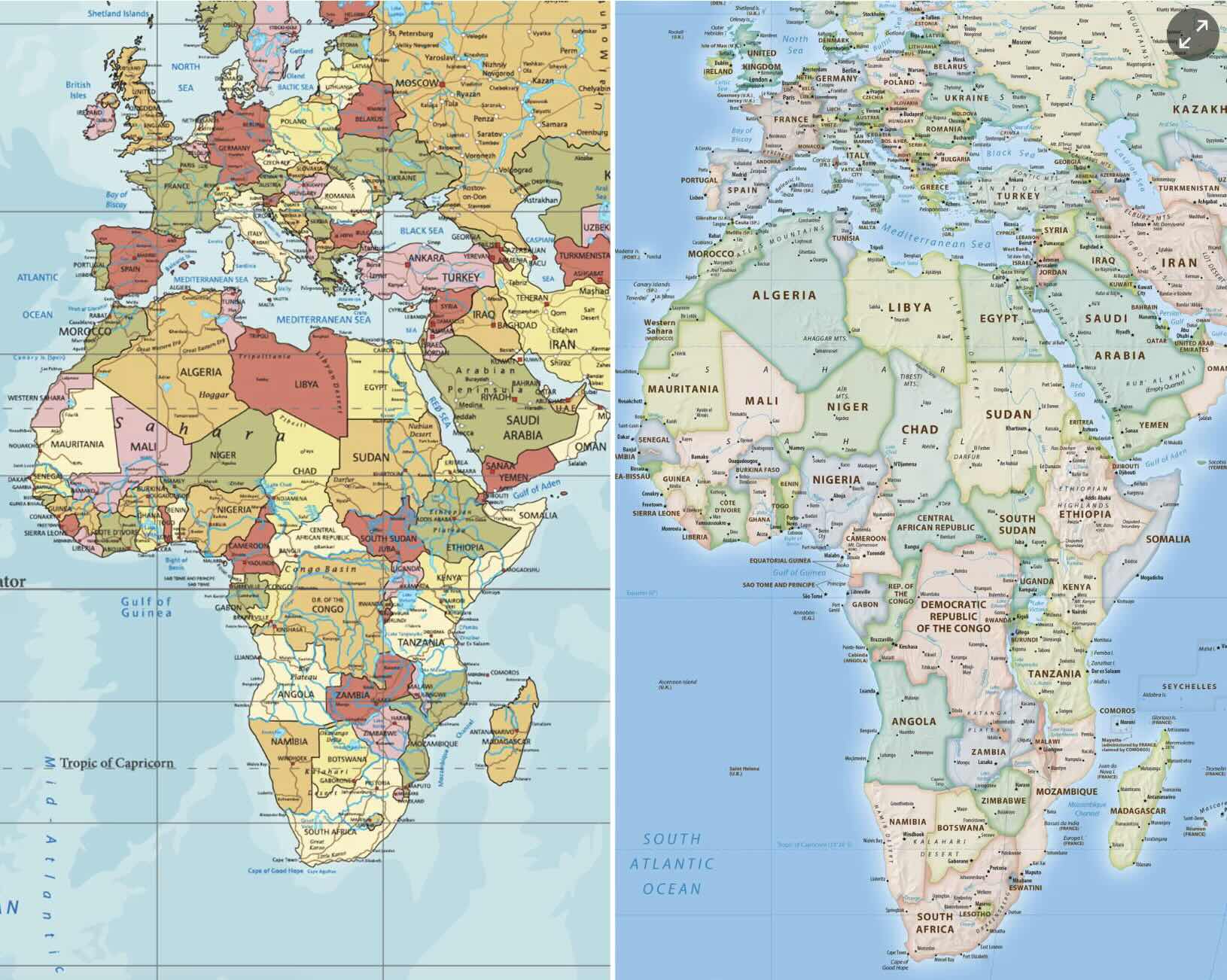
For generations, millions of people have grown up seeing a world map on which Greenland appears roughly comparable in size to Africa.
In reality, Africa is about 14 times larger.
The distortion comes from the Mercator projection, developed by Flemish cartographer Gerardus Mercator in 1569.
Mercator was designed primarily for navigation rather than accurately comparing the size of countries and continents. Its geometry preserves directions useful to sailors but increasingly enlarges land masses as they approach the poles.
That means places such as Greenland, Canada, Russia and northern Europe appear disproportionately large, while regions closer to the equator, including much of Africa, appear relatively smaller.
Africa covers approximately 30 million square kilometres and is the world's second-largest continent.
Its true scale is striking: the United States, China, India and several other countries could fit within Africa's land mass.
Yet the familiar Mercator map does not make that immediately apparent.
Africa wants the map corrected
The campaign is about more than cartography.
African governments and campaigners argue that repeatedly presenting Africa as smaller than it actually is can influence how generations perceive the continent's place in the world.
The African Union formally embraced the Equal Earth projection earlier this year and urged member states to review national education curricula accordingly.
In its February 2026 decision, the AU described distorted cartographic representation as a legacy of colonial mapping and said correcting Africa's representation was important to restoring its proper place in the global imagination.
The organisation had previously linked the campaign to a broader effort to address how Africa is represented internationally.
Togo subsequently took the campaign to the United Nations.
Supporters argue that the Equal Earth projection offers a better alternative because it preserves the relative area of countries and continents while presenting the world in a visually recognisable form.
Will Google Maps and school maps now change?
Not immediately.
A UN General Assembly resolution does not mean every Mercator map around the world will suddenly disappear.
The resolution is not an enforceable global ban.
Its longer-term importance could instead lie in influencing governments, educational institutions, publishers and technology companies when they choose which world-map projections to use.
That makes classrooms particularly significant.
If countries begin adopting equal-area maps for geography education, future generations could grow up with a substantially different visual understanding of Africa's scale.
Digital technology presents a more complicated picture. Mercator-based projections remain deeply embedded in online mapping because they have practical advantages for interactive navigation.
The debate is therefore not simply about declaring one projection "wrong" and another "right". Every attempt to represent the spherical Earth on a flat surface introduces some form of distortion.
The question is which distortion is acceptable for a particular purpose.
Mercator remains useful for navigation. But critics argue that it should not be the default map for teaching people the relative sizes of continents.
More than a new map
The campaign comes as African governments increasingly demand greater influence in international institutions and challenge inherited systems that they argue diminish the continent's weight.
Africa has 55 African Union member states and a population of more than 1.5 billion people, yet debates continue over its representation in institutions such as the UN Security Council and global financial bodies.
Changing a map will not alter those power structures.
But advocates say representation also matters symbolically.
For more than four centuries, one of the world's most recognisable maps has visually magnified parts of the northern hemisphere while compressing Africa.
The UN decision puts significant international weight behind an African argument that has gathered momentum in recent years: if the world wants to understand Africa's place in it, it should begin by seeing the continent at its actual scale.
You may also like
Category: International
Related Video: What Dangote’s proposed Lamu oil refinery could mean for East Africa
Related Explainer: Explainer: Why Kenya is moving hospitals to HMIS and what it means for SHA patients
 Facebook
 Twitter / X
 WhatsApp
 LinkedIn
 Telegram
 Reddit