
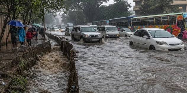
Kenya is already in the crosshairs of the forecast, with above-average October–December rains expected across Nairobi and dozens of other counties.
Kenya is heading into a potentially difficult end to the year after the World Meteorological Organisation (WMO) warned that the strengthening El Niño event could become one of the strongest recorded since at least 1950.
The WMO said on Thursday, October 8, that El Niño is expected to intensify further before reaching its peak around December 2026.
The bigger concern for Kenya is what that means on the ground.
The country's October–December short-rains outlook already points to above-average rainfall across a large part of the country. Nairobi is among the counties expected to receive more rain than usual, according to the Kenya Meteorological Service Authority's latest seasonal forecast.
The regional forecast is similarly wet.
The IGAD Climate Prediction and Applications Centre (ICPAC) has put the Greater Horn of Africa on alert for a wetter-than-normal October–December season, with increased risks of intense rainfall and flooding in vulnerable areas.
WMO: El Niño is strengthening rapidly
WMO Secretary-General Celeste Saulo said the phenomenon is now firmly established and gaining strength.
WMO forecasts give an almost 100 per cent likelihood that El Niño will continue through February 2027. The agency says the event could rank among the strongest since at least 1950.
The main indicator being watched is the Niño 3.4 index, which measures sea-surface temperature anomalies across a key part of the tropical Pacific.
That figure rose from an average 1.6°C above normal in June to 2.5°C above normal in August.
WMO now expects the October–December seasonal average to reach about 3.7°C above normal, with the peak around December.
If that forecast materialises, it would exceed the previous record of about 2.6°C recorded between November 2015 and January 2016.
That is why the latest warning matters.
This is not simply another seasonal weather shift. The Pacific Ocean is approaching an exceptionally warm state, and El Niño can alter rainfall and temperature patterns far beyond the region where it develops.
What it could mean for Kenya
For Kenya, the immediate issue is rain.
The Kenya Meteorological Service Authority's national outlook says above-average rainfall is expected in a large number of counties during the October–December season.
They include Nairobi, Kiambu, Murang'a, Nakuru, Machakos, Makueni, Kisumu, Kakamega, Kisii, Mombasa, Garissa, Mandera and many others.
Nairobi and several counties in the central highlands are expected to see the rains begin around the second to third week of October and continue into January.
KMD expects the season to feature prolonged wet spells and occasional isolated storms in several parts of the country.
That presents both an opportunity and a risk.
Good rainfall can support crops, replenish water sources and improve pasture conditions.
But heavy rain arriving over a short period can overwhelm drainage systems, trigger flash floods and landslides, damage roads and disrupt transport.
The difference between a beneficial rainy season and a damaging one can therefore come down to how well communities and authorities prepare.
Greater Horn faces heightened flood risk
ICPAC's regional outlook reinforces that concern.
The centre says there is a 90 per cent chance of enhanced rainfall over southern Ethiopia, central and southern Somalia and north-eastern Kenya.
It also projects a high likelihood of seasonal rainfall exceeding 400mm in parts of central Kenya, the Lake Victoria Basin, Somalia, Burundi, western Rwanda and western Tanzania.
ICPAC has previously identified 1997 and 2023 as useful analogue years for understanding the type of wetter conditions that can occur when similar climate drivers are present.
But the centre cautions that analogue years are only a reference. They are not a prediction of exactly what will happen in 2026.
Kenya's own meteorological service used 2015 as its closest analogue when assessing the evolution of El Niño and the Indian Ocean Dipole.
It also stressed that the analogue should not be treated as the actual forecast.
The flood warning is not a prediction of disaster
That distinction is important.
A forecast for above-average seasonal rainfall does not mean every day will be wet or that every part of Kenya will flood.
WMO says seasonal forecasts describe broad patterns and probabilities. They should be used alongside national and local forecasts, which can provide more precise information as weather systems develop.
KMD has made the same point.
Its national outlook says rainfall onset, distribution and cessation will continue to be updated through weekly and monthly forecasts. It also advises the public and other users to follow shorter-range forecasts because some weather drivers cannot be predicted reliably months in advance.
That means a county can receive a favourable seasonal rainfall outlook and still experience damaging storms.
It also means the current forecast should not be read as a guarantee of either floods or drought in a particular neighbourhood.
Another ocean signal is adding to the picture
El Niño is not acting alone.
WMO says a positive Indian Ocean Dipole, or IOD, is expected to peak in October before weakening.
The IOD can influence rainfall around the Indian Ocean and, when combined with El Niño, can strengthen the wet signal over parts of East Africa.
Kenya's August national outlook similarly linked the expected enhanced short rains to the combination of El Niño and a positive IOD.
KMD projected above-average rainfall across much of the country and warmer-than-average temperatures during the season.
The real test now is preparedness
The warning gives governments, businesses and households something that is often missing when extreme weather strikes: time.
In September, ICPAC convened a high-level El Niño preparedness forum in Addis Ababa, bringing together governments, technical experts and partners to discuss early action, regional coordination and ways of protecting communities and critical infrastructure.
For Kenya, the challenge now is turning forecasts into practical action.
That includes keeping drainage channels clear, checking flood-prone roads and bridges, protecting homes and businesses in vulnerable areas and ensuring emergency teams can respond quickly when heavy rainfall occurs.
Farmers also need to balance the promise of better rainfall with the risk of waterlogging, crop damage and erosion.
The forecast is not a call for panic.
It is a warning to prepare.
A hotter world adds another layer
The WMO also expects above-average temperatures across large parts of the world during October–December.
It cautioned that this does not mean every location will be hotter every day. Instead, the forecast points to a greater likelihood of heat extremes over the season.
Saulo said El Niño itself does not create additional heat. Rather, it releases heat already stored beneath the ocean surface.
She noted that the ocean from which El Niño is drawing that heat is itself at record warmth, meaning there is more heat available to enter the atmosphere.
That combination of an exceptionally strong El Niño signal and an already very warm global climate is what makes the current forecast particularly significant.
For Kenya, however, the most immediate question is simpler.
When the rains arrive, will the country be ready for them?
The answer will depend less on the headline number in the Pacific and more on what happens on Kenyan roads, farms, riverbanks and in flood-prone neighbourhoods over the coming weeks.
You may also like
Category: News
Related Video: Beyond Aid: How Japan Is Shaping Kenya’s SME Future | JICA Training Experience
Related Explainer: Kiharu Technical College September Intake 2026: Courses, Skills and New Opportunities
About the Author
Maureen Onyango is a journalist passionate about storytelling, life coaching and spiritual lessons. She studied at the Kenya Institute of Management and enjoys telling stories that inform, inspire and empower communities.
 Facebook
 Twitter / X
 WhatsApp
 LinkedIn
 Telegram
 Reddit