
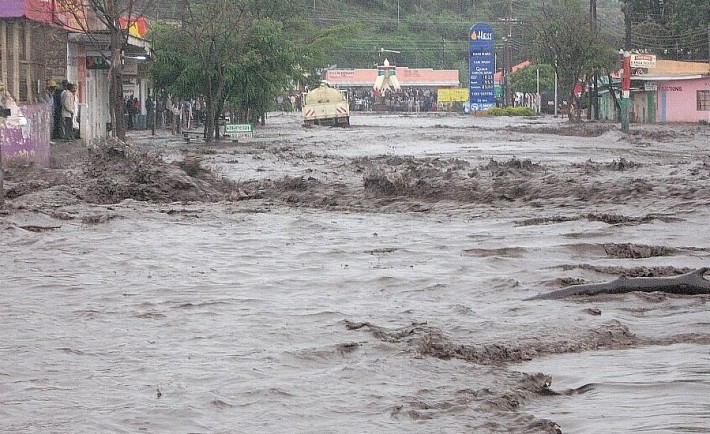
Kenya is heading into a critical few months after the World Meteorological Organisation (WMO) said El Niño is now almost certain to persist through February 2027 and is expected to strengthen into a very strong event.
The warning comes just weeks before the October–December rainy season, a period that accounts for a large share of annual rainfall in parts of Kenya and other countries across the Greater Horn of Africa.
WMO's latest update, released on Thursday, September 3, puts the likelihood of El Niño continuing through February 2027 at nearly 100 per cent.
Forecasters also expect the phenomenon to intensify further in the coming months, potentially reaching very strong levels before peaking towards the end of this year.

The development has raised the stakes for countries already dealing with climate-related shocks.
For Kenya, however, the message is not simply that more rain is coming.
The real concern is where the rain falls, how quickly it arrives and whether communities, drainage systems and emergency services are ready for it.
Kenya faces a wetter-than-normal October to December
The latest regional forecast from the IGAD Climate Prediction and Applications Centre (ICPAC) points to above-normal rainfall across much of the Greater Horn of Africa during October to December.
Kenya is among the countries expected to receive wetter-than-normal conditions.
ICPAC's regional forecast gives a 90 per cent chance of enhanced rainfall over north-eastern Kenya, while parts of central Kenya and the Lake Victoria Basin are expected to have a high likelihood of seasonal rainfall exceeding 400mm.
The forecast is particularly important because the October–December season is a major source of annual rainfall in the region. ICPAC says it contributes up to 70 per cent of annual rainfall in parts of Kenya, Ethiopia and Somalia.
But a wetter season is not automatically bad news.
The rains could replenish water sources, improve pasture and support farming after months of dry conditions.
The danger comes when rainfall becomes excessive or falls in a short period.
ICPAC has warned that heavy rainfall could increase the risk of flooding, flash floods and landslides in vulnerable areas.
That creates a difficult balance for Kenya.
Some communities need the rain.
Others may be preparing for too much of it.
A warning from the displacement front
The potential human cost is already being modelled.
A Danish Refugee Council assessment released in August estimates that flooding linked to the coming El Niño season could displace between 750,000 and three million people across Kenya, Somalia, South Sudan and Uganda, depending on the severity of the event.
In its worst-case scenario, Somalia would account for about 60 per cent of projected displacement, while Kenya would account for roughly 33 per cent.
That translates to nearly one million people in Kenya if the most severe scenario were to materialise.
But the figure needs to be understood correctly.
It is not a forecast that one million Kenyans will definitely be displaced. It is the upper end of a scenario model based on rainfall forecasts, flood exposure, river systems, seasonal patterns and previous displacement.
The Danish Refugee Council says its scenarios will be updated as weather forecasts change.
That distinction matters because El Niño does not produce identical effects everywhere.
Strong El Niño does not mean the same weather everywhere
WMO has cautioned against treating the strength of El Niño as a direct measure of how severe its effects will be in every country.
The phenomenon changes rainfall and temperature patterns around the world, but local impacts are influenced by other climate drivers.
For East Africa, the Indian Ocean Dipole is particularly important.
WMO expects a positive Indian Ocean Dipole phase to develop, while ICPAC also says the combination of El Niño and a positive IOD is expected to favour above-normal rainfall over much of the eastern part of the region.
This is why national and regional forecasts remain more useful for planning than the El Niño label alone.
In Kenya, authorities will need to watch local rainfall forecasts closely as the season approaches.
From drought to flood risk
The timing of the warning is significant.
Kenya and other parts of the Greater Horn have just come through a period in which several areas experienced below-normal rainfall.
ICPAC's June–September outlook had warned of below-average rainfall in western and coastal Kenya and other parts of the region.
Now the climate picture is shifting.
The same region could move from water stress to flood risk within months.
ICPAC's August El Niño assessment said western and north-western Kenya had already experienced a poor June–September season, raising concerns over agricultural production.
At the same time, it warned that excessive rainfall in the eastern parts of the region could cause loss of life, crop damage, infrastructure destruction and disruptions to health and nutrition services.
That creates a particularly difficult planning challenge.
Authorities must prepare for flooding while some communities are still dealing with drought-related losses.
Guterres: "We are in uncharted waters"
UN Secretary-General António Guterres has urged governments to treat the latest climate warning seriously.
“El Niño is being supersized before our eyes,” Guterres said in a statement carried by WMO.
He warned that rising sea temperatures were increasing the risk of extreme weather and called for faster action to protect vulnerable communities.
WMO Secretary-General Celeste Saulo was equally direct.
“El Niño ... has the potential to deliver a massive blow to communities and economies across the world,” she said.
She said the organisation was stepping up preparedness and early-warning efforts because of the scale of the emerging event.
The warning is also a test of preparedness
For Kenya, the next few weeks may be as important as the rains themselves.
The country has experienced repeated flooding in recent years, exposing weaknesses in drainage, settlement planning, roads and emergency response.
The latest forecasts give authorities an opportunity to act before the heaviest rains arrive.
That includes clearing drainage channels, identifying communities in flood- and landslide-prone areas, protecting critical infrastructure, checking evacuation routes and ensuring early warnings reach people in time.
It also means avoiding a one-size-fits-all response.
Some parts of Kenya may need flood preparations.
Others may still be dealing with dry conditions and depleted water and pasture resources.
WMO's latest bulletin makes one point clear: the climate signal is unusually strong, but the local consequences will vary.
El Niño is now almost certain to remain in place into early 2027.
What happens on the ground will depend partly on how well governments and communities respond before the rains arrive.
For Kenya, the warning is therefore not simply about a wet season.
It is a window to prepare.
You may also like
Category: News
Related Video: Dolly Parton’s Family Announces Her Passing in Emotional Tribute
Related Explainer: Fact Check: Did elephants save people during Nepal’s floods?
About the Author
Maureen Onyango is a journalist passionate about storytelling, life coaching and spiritual lessons. She studied at the Kenya Institute of Management and enjoys telling stories that inform, inspire and empower communities.
 Facebook
 Twitter / X
 WhatsApp
 LinkedIn
 Telegram
 Reddit